
Crater Lake (my mile 1192, trail mile 1821) to Charlton Lake (my mile 1296, trail mile 1925)
Our day off in Fort Klamath was sorely needed, as both Tidbit and I could feel our bodies protesting against the longer days we’d been hiking since the Oregon border. By the time we reached Crater Lake it felt like we were both running on empty. After a night at the Aspen Inn we walked to the Fort Klamath post office, which is only open for two hours a day.
We collected our resupply box and I picked up my new Dirty Girl gaiters, replacing my old pair of Salomons that I’d worn out. A local artist named John offered us a ride on our way out of the post office, then drove us back up the highway to Crater Lake in his camper van.
A bear was crossing the highway just before the park entrance, then scurried off the road as the van approached. We stopped, and I managed to get a great photo of the bear as it paused to look back at us.

Tidbit hopped out at Mazama Village and took the trolley up to the rim, while John dropped me at the trailhead and I walked the 4.5-mile alternate that took me to the same spot. Taking the Crater Lake Rim Trail is technically cheating since it’s not the PCT but almost everybody does it because the PCT doesn’t actually go to Crater Lake.
Instead, it takes a wide arc around the lake that is around five miles longer. I’m not so much of a purist that I’d miss out on such a highlight just to stick to the “official” trail, but I want my path from Mexico to Canada to be connected by continuous footsteps. Thus, I panted my way up the steep climb from the highway to the rim while Tidbit relaxed at the Rim Village cafe.
I power walked the whole way to the cafe, and surprised Tidbit when I rocked up earlier than she’d expected. We strolled out to the rim, and I got my first view of Crater Lake. As advertised, it was enormous. The lake lies at the bottom of a volcano’s caldera, which stretches all the way to the horizon when viewed from the rim. The original volcano, Mount Mazama, tore itself apart in a massive eruption around 7700 years ago, creating the huge crater.

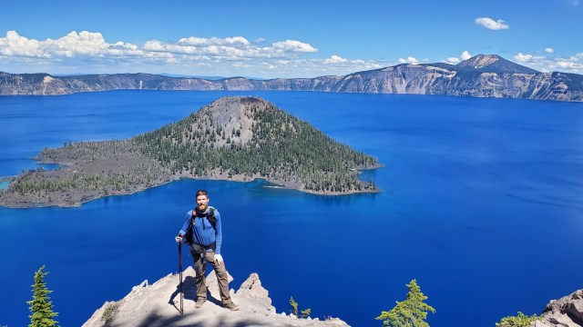
The lake is fed only by snowmelt and rain, and sparkled a brilliant blue beneath me on what was a cloudless day. In the middle of it all was Wizard Island, the beginnings of a new volcano, jutting out of the lake near its western shore. Hordes of tourists swarmed the rim trail closest to the car park, but disappeared as we followed the trail away from the village and around to the north side of the rim.
Snow covered the north end of the trail, forcing us to walk along the road for a stretch. We stopped for one last look at the lake at its northern end, then rejoined the PCT a few miles later. We trekked through nine miles of flat forest in the dying light to make it to a water cache at a junction with a forest road just outside the park boundary.
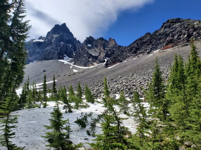
We climbed half way up Mount Thielsen the next morning, then followed the trail as it skirted the mountain’s slopes. We hit snow on the north face, and had to strap on our microspikes for a steep descent into the forest. We had no idea we were descending into insectoid hell.
Melting snow, as it turns out, creates a lot of stagnant ponds, which are a favourite breeding ground for mosquitos. Thousands of them swarmed us as soon as we reached the cover of trees, forcing us to cover our faces with our bug nets. I was glad to be wearing long pants. We hiked on, praying that the swarms would dissipate somewhere. They didn’t.

Tidbit and I had decided to push all the way to Windigo Pass, making it a 30-mile day. From Windigo, Tidbit could take a 20-mile alternate to the resort at Shelter Cove while I would hike the PCT, which is eight miles longer. The 30-mile was tough but fast, as the mosquitos left us no opportunities to take a break. They were in absolute plague proportion at the pass, so I put on my rain gear and sprayed myself with DEET before making dinner. I dived into the tent the second I’d finished eating.

I wasn’t really in the mood to hike 28 miles the next morning, especially while being attacked by yet more mosquitos, but I resolved to push on. The extra miles would earn me a zero in Bend, the next town, while keeping me on schedule to finish my hike in mid September.
It was a miserable day of hiking, with no reprieve from the winged blood-suckers. I scoffed my lunch while they buzzed around my face, and jogged sections where they were particularly bad. The snow-covered Diamond Peak was the day’s only highlight, but I couldn’t stop to appreciate the views.

My ankle began to complain five miles from the resort, and it was nearly 9PM by the time I limped to the campground. Tidbit had already set up the tent and had spent the afternoon hanging out with other hikers after getting a ride from the camp hosts at Crescent Lake, half way between Windigo Pass and Shelter Cove.

We lingered around the resort past lunch time the next day as we washed our clothes and filled up on scrambled eggs and hamburgers at the resort cafe. When we finally rolled out at 2:30 I was feeling queasy. I was trying to stop myself vomiting as we walked the road out of the resort, but when we started going uphill I couldn’t hold it any longer. I puked in the ditch, and spent a few minutes feeling sorry for myself before we hiked on.
I figured I’d have lost a bunch of electrolytes when I retched, so I dropped some Nuun tablets into my water bottle. We made it 14 miles before we decided to make camp, where we were again swarmed by millions of evil f**king mosquitos. I munched on a Clif bar in my tent, not willing to brave the mozzies to cook.

As I lay back in my sleeping bag, I felt my heart flutter – just like it had back near Idyllwild. I held my finger against my neck and took my pulse. It had almost no discernible rhythm. I realised I’d slipped back into atrial fibrillation. I went to sleep and hoped I would cardiovert naturally.
I was still in A-fib when I woke up the next morning. Elk Lake was 31 miles ahead. I hoped my heart would return to normal on the trail, so we packed up camp and headed north. When we reached Charlton Lake four miles later it was still beating erratically. I tried meditating, coughing a lot and a bunch of other tricks to stimulate cardioversion, but with no luck. We spotted a couple of canoers as we worked out what to do, but decided to push on.

A mile later the trail began a gentle climb which left me panting for breath. We stopped by the side of the trail as I agonised over what to do. I remembered Frodo’s advice to us hikers back in San Francisco – “make good choices” – and decided to turn back. Tidbit and I returned to the lake, and found the car park the canoers had come by.
We waited for an hour or so until they returned, and I explained my situation. They were a friendly elderly couple, and agreed to take us back to civilisation. The couple were staying nearby in Oakridge, but drove me all the way to the nearest hospital in Eugene.

I was admitted right away, and was immediately attached to a plethora of electrodes. I’d been expecting a long stay, like my first hospitalisation at Eisenhower, but the doctors at PeaceHealth wasted no time. Given I’d already been diagnosed and knew exactly what was going on there wasn’t much to do but shock me back to normality. They put me under, and then it was all over. I walked out of hospital less than three hours after I’d arrived, sporting a new bright red burn mark on my chest from the defibrillator.

I was stressed out and worried my hike was over. Now stranded in Eugene, we had no idea what to do. I booked us a room at a hotel downtown, and we ordered a Lyft to take us there. The driver who picked us up, a cheery local guy named Chris, offered to take us on a tour of Eugene since I was new to town. He switched off the meter and took us to the spot where legendary Olympic distance runner Steve Prefontaine died in a car accident back in the 70s.

Eugene is the US capital of track and field athletics. The University of Oregon, which is based in the town, is the training ground for America’s Olympic track athletes. Tidbit, a former college track runner, was nerding out. We drove by Hayward Field then stopped for ice cream at Prince Pucklers, a local cult favourite. “Oh hey, that’s Marcus outside,” said Chris. “He’s a Heisman Trophy winner.”
I’m a big football fan, so I went outside to see who it was. It was Tennessee Titans quarterback and Oregon Ducks alum Marcus Mariota. “Holy shit, are you Marcus Mariota?” I asked. “Yep,” he replied. He let me get a photo, then we chatted for a second about the trail. It was a happily bizarre end to my weirdest day on the trail so far.

Yikes! Take care of yourself!! Great story, and glad it turned out okay.
You do realise you are giving me more grey hairs. Your photos are amazing. Take care.