
I tossed and turned all night at my camp by Palisade Creek. My restless mind’s focus see-sawed between the sounds of the raging torrent running by my tent, and the irregular thump…thump…………..THUMP of my malfunctioning heart. I tried to calm myself, but kept giving in to the temptation to check my pulse. My heart had naturally reverted to its normal rhythm after several earlier episodes, and I was hoping it would do so again. I wondered what I would do if it didn’t. There were no good options.
The Muir Trail Ranch, probably my closest bailout point, was on the other side of Muir Pass. To get there I’d have to climb thousands of feet over five trail miles, much of it in snow, then make a long and arduous descent on the other side. Just setting up my tent had left me breathless and exhausted, and attempting the pass would put enormous strain on my heart. If I did so, I was risking a heart attack.
A trail leading out of the mountains over Bishop Pass was two miles behind me, but it was 16 miles long and involved a similarly taxing climb. Worse, it ended at a remote trail head parking lot where there was no guarantee of finding help. The mum and daughter I was camped with were heading in that direction, but it would take them days to cover the distance and they couldn’t do much for me anyway. I knew I needed to get out of the mountains as soon as possible.

My only option was a back country ranger’s cabin that I knew was nearby, hidden just off the trail near the Bishop Pass / PCT junction. I’d been listening to an audio book about back country rangers, Eric Blehm’s The Last Season, and knew that they spent much of their time away from their cabins, patrolling their vast territories. I knew a ranger would have a radio, and could contact park headquarters about an evac. I wondered whether that was even possible in this canyon – had I seen anywhere that a helicopter might land? – but it was the best of my limited options.
My heart was still in A-fib when I woke, so I put my plan into action. I slowly packed up my gear, having to stop several times to catch my breath, and explained to the mum camped nearby what was happening. She offered to come with me, but it would take her and her daughter a long time to get moving. It was only two miles of downhill trail to the ranger’s cabin, so I told them I’d go on ahead. I figured if I ran into trouble I could sit and wait for them to arrive.
I slowly retraced my steps to the bottom of LeConte Canyon, annoyed to be surrendering the elevation I’d worked so hard to gain just a day before. I followed the trail along the banks of Palisade Creek for about an hour before I reached the junction with the Bishop Pass Trail. 16 miles down that trail was civilisation, but I knew I wouldn’t make it. Instead I headed deeper into the woods, following a marked spur trail that led to the ranger’s cabin. It was a cosy-looking wooden thing, with a pitched roof and a single window. I stepped onto the porch and found a note pinned to a message board.

As I’d feared, the ranger was out on patrol. The note explained that they may not be back for days. I knew I only had one option left.
Since I started the trail, I’d been carrying a small personal locator beacon in the hip pocket of my pack. I’d bought the device about three years earlier, and always carried it with me on the Bibbulmun Track back home – even on day hikes – in case of emergency. It required clear access to the sky, so I turned around once more and began climbing towards a treeless granite outcrop I’d passed on the way down. Fortunately, it was only a few hundred feet away from the cabin.
I reached the outcrop, removed my pack, and scrambled up to the top of a huge boulder by the side of the trail. Mountains on all sides of the canyon still partially obscured the sky, but there was still plenty of cloudless sky above me. I hoped that somewhere in all that clear blue was a satellite that could receive my signal. I gingerly unclasped the beacon’s long antenna and pointed it straight upright. I read and re-read the instructions on the back of the device before pressing the SOS button. I held it down, counting the five seconds it needed to prevent accidental activation. A small LED lit up in red, then began flashing green. It was broadcasting.

There was nothing to do but wait, so I left the PLB on top of the rock and scrambled back down to my pack, which I’d left lying in the shade by the trail. I wondered how long help would take to come. Over the next few hours, I strained my ears listening for rotor blades, but heard nothing. Morning turned to afternoon, so I had lunch under the tree.
Around 2PM, a young ranger came scrambling up the granite. She was facing away from me, searching for the PLB, so I called out to her. “Are you Ben?” she asked. I’d registered the PLB with the Australian Maritime Safety Authority before I’d left. Obviously, she’d been relayed my information. She introduced herself as Ranger Muller. “Sorry I took so long, I was on top of Bishop Pass when you activated it,” she said. “Hey, it’s the back country,” I replied. “That’s part of the deal.” She asked what was wrong with me, and I began to explain about atrial fibrillation. To my surprise, she knew about it. Another hiker with the same condition had suffered an episode on Kearsage Pass, but had been close enough to the trail head to evacuate himself.
Ranger Muller led me back to the cabin and unlocked the door. Inside it was just as I’d imagined, with a sleeping loft, a basic kitchen, books stacked to the ceiling, and a pantry packed with tinned food. Ranger Muller sat me down at the table and gave me a basic physical. She stepped outside to radio the results back to park headquarters. When she returned, she told me the park service was going to evacuate me by helicopter.
Ranger Muller led me up a hill to another granite outcrop, the designated landing zone for LeConte Canyon. I sat on a rock while she cleared the area of tree branches and rocks, then we sat and waited. She told me she was in her early 20s, and was originally from Colorado. She’d joined the park service only a couple of years earlier and worked as a ski guide in the winter and a back country ranger in the summer. What a life. I kept thanking her profusely for coming to my rescue, which she appreciated. She told me there was a growing sense of entitlement among people who visit America’s national parks, and a lack of respect for what being in the wilderness really means – that you’re knowingly going far away from help, and any you receive should be taken as a blessing.
20 minutes later, we heard the drone of helicopter rotors in the distance. A minute later, a small, green rescue chopper appeared over the trees. It swooped down over the outcrop before gently touching down on the rock, kicking up dust in all directions. As the engine wound down, a medic hopped out and conversed with Ranger Muller. The pilot hopped out too, and handed the ranger a handful of mangos. Back country rangers live most of their seasons off non-perishable foods, so my SOS created a rare excuse for a fresh produce delivery.
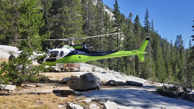
The medic, a friendly-middle aged woman, gave me another physical on the ground before donning me in a flight suit and hooking me up to an oxygen tank. She gave me a quick safety briefing and told me how to work the headset. I said goodbye to Ranger Muller and climbed into the back seat of the chopper. The pilot spooled up the engine and gently lifted us off the ground. As we got higher I could see LeConte Canyon spread out before me, while more mountains revealed themselves in the distance. I could see the spine of the Sierra Nevada range stretching southward. I wondered where the trail I’d hiked for the past week wound its way between the peaks.


We flew over the top of Moro Rock, then dropped thousands of feet into park headquarters at Ash Mountain. It had only been moderately warm on the trail, but even before we landed I could feel the air outside was scorching at this lower elevation. An ambulance was waiting for me at the helipad.
I was transferred into the ambulance, where the EMT hooked me up to a heart monitor. “Right now you’re in sinus rhythm,” he told me. At some point between activating the PLB and landing at Ash Mountain my heart had cardioverted on its own. I could have been annoyed, but I was just glad to have made it out safely.

I turned on my phone and it blew up with messages from my dad. I’d forgotten I’d listed him as the emergency contact when I registered the PLB, and he’d received a phone call the minute I activated it. The call came in the middle of the night back in Australia, and he’d got no sleep after that. I reassured him I was fine and called my mum.
The ambulance took me to Visalia, a town with a major hospital in California’s central valley, on the west side of the Sierra. They checked me out, confirmed I was no longer in A-Fib, and discharged me.
I’d woken up in the high Sierra wilderness, and by the afternoon I was standing on a scorching sidewalk in a dusty desert town. I had no idea what I would do or where I would go, but decided I’d leave that for tomorrow. I booked into a hotel next door, ordered pizza, and slept.
Ben, when are you going to be ‘smart’ and leave while the going is good??? You have done amazing things – seen absolutely amazing scenery and had an adventure that most people will never see or experience. So, how about it Ben? Give your parents a break from the worry and stress!! PLEASE??
Hi Lia, I got off the trail two months ago – this was the end of my hike.
Wowsers, what a story. Glad you made it out safely, but shows how easily things can go wrong. Appreciate you sharing with us.