
Seiad Valley (my mile 1027, trail mile 1656) to Crater Lake (my mile 1192, trail mile 1821)
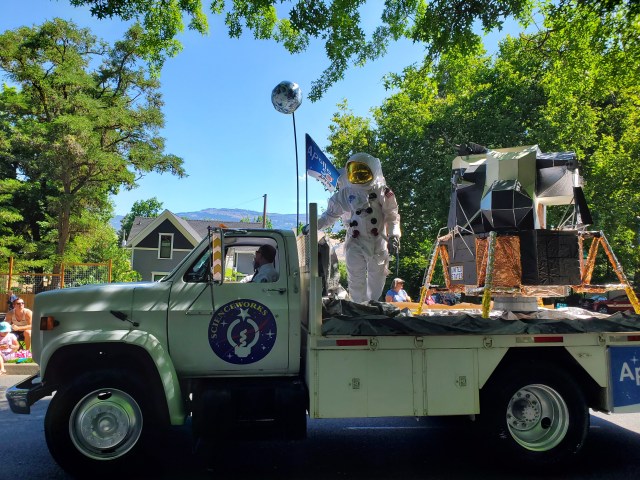
Independence Day in Ashland was like a city-wide party. Tidbit and I walked along the main street as we watched the miles-long parade, then enjoyed hearty lunches at an English pub (the irony). At a street fair, we watched pro-choice protestors face off with pro-life protestors welding signs with pictures of aborted foetuses, until the police got involved. Only in the land of the free.
We stopped by a microbrewery on our way home, then sprawled out on our trail angel’s garage floor to pack resupply packages for the trail ahead. I also finally managed to replace my trekking pole tips, which had been worn down to nubs. It was tricky to get the old tips off, but we eventually managed with the help of boiling water and some pliers.


I could have stayed in Ashland for weeks – maybe even a lifetime – but with full stomachs and rested legs, Tidbit and I decided it was time to get back on the trail. That was a little easier said than done, as we’d skipped up from Seiad Valley for Independence Day. Luckily a trail angel named Tor responded to our Facebook plea for help and offered us a ride. He picked us up from the Ashland UPS store where we’d mailed resupply boxes.
Tor dropped us at Seiad around noon, but warned us that the trail ahead was overgrown with poison oak that was impossible to avoid. He suggested we hike a parallel forest service road that makes the same 4500-foot climb before rejoining the trail. We took his advice, and spent all afternoon gradually working our way up and out of the valley. It was hot, especially in some recently burnt areas that offered hardly any shade. We stopped at a waterfall near the top and cooled off.

At the top we ran into Grit, who’d just hiked up the trail. I asked her what the poison oak was like – she told me it was no big deal. My inner purist wishes I’d stuck with the trail. That’s the problem with listening to warnings on the trail: sometimes the information is out of date, and it’s pretty much always subjective. One person’s “impassable overgrowth” is just a minor annoyance to others.
Just before camp that night I spotted my second bear of the trail. As I climbed a ridge, I saw the jet-black bear scurrying down the hill at full speed to get away from me. We stopped for the night at a spot with a spectacular view of the valley below, with Mount Shasta looming in the distance. I watched my last sunset in California (for now) before crawling into my sleeping bag.


We reached the Oregon state line late the next day after some more ridge climbing, and made our first camp in the state at another beautiful spot. The sky put on a show, as if to welcome us to the beaver state. I’d crossed into Oregon 629 miles earlier than most PCT hikers thanks to our decision to flip north, but reaching my second state still felt like a huge achievement.


My first full day in Oregon was spent hiking through green pine forests full of moss and lichen, with many great view of the yellowed grassy hills of the Rogue Valley. Some graffiti on a trail marker gave us a warning: “Don’t believe their lies, Oregon is NOT flat”. Hikers often describe Oregon as “flat” because it is, comparable to the Sierra section most have just hiked through, but a glance at the state’s elevation profile reveals it’s not a walk in the park. Sure, the highest point is less than 8000 feet, but there is almost no point in the whole state where you’re not either climbing a big hill or coming down it.

By the early evening Tidbit and I reached Callahan’s, a lodge on the highway that leads to Ashland. The resort is famously hiker-friendly, and offers bottomless spaghetti bolognese to hikers for $14. I had two big plates of it. We picked up the first of our resupply packages from the front desk and stuffed the contents into our food bags. Another box was open on the table, full of Clif bars and peanut butter. Attached to it was a printed email from the sender, explaining that he’d quit his hike and wanted the contents given away to other hikers. I salvaged three or four Clif bars and added them to my food bag. Score! Once packed we hiked out into the night, making it two more miles down the trail before we camped near a dry stream.


We made long miles the next two days, pushing to make it to Fish Lake resort. The second day was 29 miles – Tidbit’s longest ever – which we hiked in record time in order to make it to the restaurant at the nearby Lake of the Woods resort before their advertised 9PM closing time. We practically skipped over 10 miles of volcanic rocks in barely three hours to make it to the highway by 7:15PM. Tidbit, who usually hikes behind me, blazed past me about an hour before the end. She was breathing like a woman in labour. “If I slow down I won’t be able to keep going,” she said. “I’m just running off the adrenaline from the pain.”

We tried desperately to get a hitch, but car after car passed us by without slowing down. Finally, just before 8, an old man driving home to Klamath Falls pulled over in his pickup truck and gave us a ride. We reached the resort by 8:15, and limped up to the restaurant. I tried the door, but it only rattled. Two other hikers we knew, Shelby and Super Trooper, unlocked the door and came outside a moment later. “Are they closed?” I asked incredulously. “I don’t know, we just ate,” Super Trooper said.
I walked in to find the waitress mopping the floor. “Are you closed?” I asked. “Yeah, it was really slow so we closed early,” she said. It took all of my self-control not to have a full-blown tantrum. “But we hiked so far to be here before 9!” I said. “Sorry,” was all she could offer.
I stormed outside and gave the bad news to Tidbit. We were both tired and grumpy. Super Trooper offered us a ride back to Fish Lake (on the same highway) with his family, who had come to collect him and Shelby for a wedding. We were about to take up their offer when the restaurant manager came outside, evidently having taken pity on us. “I can make you guys a couple of burgers if you want,” he said. We got them to go, and rode back to Fish Lake with Super Trooper and Shelby.
We slept in the next morning, and spent the first half of the day doing laundry, showering and charging our electronics. We finally hiked out at 2PM, and got a hitch back to the trail. We made it 18 miles by sunset and camped in a burn area. As I was making dinner we both heard what sounded like a low animal call. We couldn’t work out if it was a bear or an elk, or something else. I wasn’t sure I wanted to know.

It took Tidbit and I two more days to get to Crater Lake, hiking through bright green forests, areas scarred by fire and past snowy peaks. At a junction a day’s hike south of Crater Lake Tidbit and I both separately went the wrong way, thanks to some idiot who’d marked an arrow on the ground pointing in the wrong direction. I made it nearly a mile before I noticed, and had to backtrack. Lesson learnt: always check the map.
The trail was surprisingly dry and dusty, requiring us to carry heavy loads of water for long stretches. The weight wore us both down, and by the time we reached Mazama Village, on the outskirts of Crater Lake National Park, we needed a break. We booked a room at the Aspen Inn in nearby Fort Klamath, where we needed to pick up packages anyway, and took the afternoon off.
The motel’s owners were incredibly friendly. They didn’t have any washing machines, but they gave us a bucket and a drying frame so we could do laundry ourselves. For the first time since Etna I slept in a real bed. It was heavenly.


